Geography
From The Art and Popular Culture Encyclopedia
| Revision as of 07:37, 11 July 2017 Jahsonic (Talk | contribs) ← Previous diff |
Current revision Jahsonic (Talk | contribs) |
||
| Line 1: | Line 1: | ||
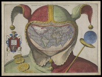
| + | [[Image:Fool's Cap World Map by anonymous.jpg|thumb|left|200px|''[[Fool's Cap World Map]]'' (c. 1590s) by anonymous]] | ||
| + | {| class="toccolours" style="float: left; margin-left: 1em; margin-right: 2em; font-size: 85%; background:#c6dbf7; color:black; width:30em; max-width: 40%;" cellspacing="5" | ||
| + | | style="text-align: left;" | | ||
| + | "[[War]] is God's way of teaching Americans [[geography]]."--Paul Rodriguez | ||
| + | <hr> | ||
| + | "OUR [[earth]] is but as an atom in [[space]], a star amongst stars. Yet, to us who inhabit it, it is still without bounds, as it was in the time of our [[primitive people|barbarian ancestors]]. Nor can we foresee the period when [[terra incognita|the whole of its surface will be known to us]]."--''[[The Earth and Its Inhabitants]]'' (1875–1894) by Élisée Reclus | ||
| + | |} | ||
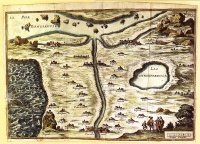
| [[Image:Carte du tendre.jpg|thumb|right|200px|The ''[[Map of Tendre]]'' (''Carte du Tendre'') is a French map of an [[imaginary country]] called ''[[Tendre]]''. It shows a geography entirely based around the theme of [[love]]]] | [[Image:Carte du tendre.jpg|thumb|right|200px|The ''[[Map of Tendre]]'' (''Carte du Tendre'') is a French map of an [[imaginary country]] called ''[[Tendre]]''. It shows a geography entirely based around the theme of [[love]]]] | ||
| {{Template}} | {{Template}} | ||
| The study of the physical [[structure]] and [[inhabitant]]s of the [[Earth]]. | The study of the physical [[structure]] and [[inhabitant]]s of the [[Earth]]. | ||
| - | ==Notable geographers==<!-- Please respect chronoogial order --> | ||
| - | * [[Eratosthenes]] (276BC – 194BC) – calculated the size of the Earth. | + | ==History== |
| - | * [[Strabo]] (64/63 BC – ca. AD 24) – wrote [[Geographica]], one of the first books outlining the study of geography. | + | The [[ancient Greeks]] divided the world into three [[continents]], [[Europe]], [[Asia]], and [[Libya]] (Africa). |
| - | * [[Ptolemy]] (c.90–c.168) – compiled Greek and Roman knowledge into the book [[Geographia]]. | + | |
| - | * [[Al Idrisi]] (Arabic: أبو عبد الله محمد الإدريسي; Latin: Dreses) (1100–1165/66) – author of Nuzhatul Mushtaq. | + | |
| - | * [[Gerardus Mercator]] (1512–1594) – innovative [[cartography|cartographer]] produced the [[mercator projection]] | + | |
| - | * [[Alexander von Humboldt]] (1769–1859) – Considered Father of modern geography, published the Kosmos and founder of the sub-field biogeography. | + | |
| - | * [[Carl Ritter]] (1779–1859) – Considered Father of modern geography. Occupied the first chair of geography at Berlin University. | + | |
| - | * [[Arnold Henry Guyot]] (1807–1884) – noted the structure of glaciers and advanced understanding in [[Glacial motion|glacier motion]], especially in fast ice flow. | + | |
| - | * [[William Morris Davis]] (1850–1934) – father of American geography and developer of the [[cycle of erosion]]. | + | |
| - | * [[Paul Vidal de la Blache]] (1845–1918) – founder of the French school of geopolitics and wrote the principles of human geography. | + | |
| - | * Sir [[Halford Mackinder|Halford John Mackinder]] (1861–1947) – Co-founder of the [[London School of Economics|LSE]], [[Geographical Association]] | + | |
| - | * [[Ellen Churchill Semple]] (1863–1932) – She was America's first influential female geographer. | + | |
| - | * [[Carl O. Sauer]] (1889–1975) – Prominent cultural geographer | + | |
| - | * [[Walter Christaller]] (1893–1969) – human geographer and inventor of [[Central place theory]]. | + | |
| - | * [[Yi-Fu Tuan]] (born 1930) – Chinese-American scholar credited with starting Humanistic Geography as a discipline. | + | |
| - | * [[Karl Butzer|Karl W. Butzer]] (1934–2016) – An influential German-American geographer, cultural ecologist and environmental archaeologist. | + | |
| - | * [[David Harvey (geographer)|David Harvey]] (born 1935) – Marxist geographer and author of theories on spatial and urban geography, winner of the [[Lauréat Prix International de Géographie Vautrin Lud|Vautrin Lud Prize]]. | + | |
| - | * [[Edward Soja]] (1941–2015) – Noted for his work on regional development, planning and governance along with coining the terms [[Synekism]] and Postmetropolis, winner of the [[Lauréat Prix International de Géographie Vautrin Lud|Vautrin Lud Prize]]. | + | |
| - | * [[Michael Frank Goodchild]] (born 1944) – prominent GIS scholar and winner of the RGS founder's medal in 2003. | + | |
| - | * [[Doreen Massey (geographer)|Doreen Massey]] (1944–2016) – Key scholar in the space and places of [[globalization]] and its pluralities, winner of the [[Lauréat Prix International de Géographie Vautrin Lud|Vautrin Lud Prize]]. | + | |
| - | * [[Nigel Thrift]] (born 1949) – originator of [[non-representational theory]]. | + | |
| + | The [[Hellespont]] formed the border between Europe and Asia. The border between Asia and Libya was generally considered to be the Nile river, but some geographers, such as Herodotus objected to this. Herodotus argued that there was no difference between the people on the east and west sides of the Nile, and that the [[Red Sea]] was a better border. The relatively narrow habitable band was considered to run from the Atlantic Ocean in the west to an unknown sea somewhere east of India in the east. The southern portion of Africa was unknown, as was the northern portion of Europe and Asia, so it was believed that they were circled by a sea. These areas were generally considered uninhabitable. | ||
| ==See also== | ==See also== | ||
| * [[Flat earth]] | * [[Flat earth]] | ||
Current revision

|
"War is God's way of teaching Americans geography."--Paul Rodriguez "OUR earth is but as an atom in space, a star amongst stars. Yet, to us who inhabit it, it is still without bounds, as it was in the time of our barbarian ancestors. Nor can we foresee the period when the whole of its surface will be known to us."--The Earth and Its Inhabitants (1875–1894) by Élisée Reclus |

|
Related e |
|
Featured: |
The study of the physical structure and inhabitants of the Earth.
History
The ancient Greeks divided the world into three continents, Europe, Asia, and Libya (Africa).
The Hellespont formed the border between Europe and Asia. The border between Asia and Libya was generally considered to be the Nile river, but some geographers, such as Herodotus objected to this. Herodotus argued that there was no difference between the people on the east and west sides of the Nile, and that the Red Sea was a better border. The relatively narrow habitable band was considered to run from the Atlantic Ocean in the west to an unknown sea somewhere east of India in the east. The southern portion of Africa was unknown, as was the northern portion of Europe and Asia, so it was believed that they were circled by a sea. These areas were generally considered uninhabitable.
See also

