Map of Tendre
From The Art and Popular Culture Encyclopedia
| Revision as of 19:50, 11 May 2010 Jahsonic (Talk | contribs) ← Previous diff |
Revision as of 19:52, 11 May 2010 Jahsonic (Talk | contribs) Next diff → |
||
| Line 1: | Line 1: | ||
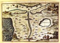
| [[Image:Carte du tendre.jpg|thumb|right|200px|The ''[[Map of Tendre]]'' (''Carte du Tendre'') is a French map of an [[imaginary country]] called ''[[Tendre]]'' produced by several hands (including [[Catherine de Rambouillet]]). It appeared as an engraving (attributed to [[François Chauveau]]) in the first part of [[Madeleine de Scudéry]]'s 1654-61 novel ''[[Clélie]]''. It shows a geography entirely based around the theme of [[love]] according to the [[Précieuses]] of that era: the river of Inclination flows past the villages of "Billet Doux" ([[love letter|Love Letter]]), "Petits Soins" (Little Trinkets) and so forth.]] | [[Image:Carte du tendre.jpg|thumb|right|200px|The ''[[Map of Tendre]]'' (''Carte du Tendre'') is a French map of an [[imaginary country]] called ''[[Tendre]]'' produced by several hands (including [[Catherine de Rambouillet]]). It appeared as an engraving (attributed to [[François Chauveau]]) in the first part of [[Madeleine de Scudéry]]'s 1654-61 novel ''[[Clélie]]''. It shows a geography entirely based around the theme of [[love]] according to the [[Précieuses]] of that era: the river of Inclination flows past the villages of "Billet Doux" ([[love letter|Love Letter]]), "Petits Soins" (Little Trinkets) and so forth.]] | ||
| {{Template}} | {{Template}} | ||
| - | :''[[Reclaiming our humanity is reinventing La Carte du Tendre]]'' | + | :''[[gallantry]]'' |
| - | + | ||
| The '''Map of Tendre''' (''Carte du Tendre'') was a French map of an [[imaginary country]] called ''Tendre'' produced by several hands (including [[Catherine de Rambouillet]]). It appeared as an engraving (attributed to [[François Chauveau]]) in the first part of [[Madeleine de Scudéry]]'s 1654-61 novel ''[[Clélie]]''. It shows a geography entirely based around the theme of [[love]] according to the [[Précieuses]] of that era: the river of Inclination flows past the villages of "Billet Doux" ([[love letter|Love Letter]]), "Petits Soins" (Little Trinkets) and so forth. | The '''Map of Tendre''' (''Carte du Tendre'') was a French map of an [[imaginary country]] called ''Tendre'' produced by several hands (including [[Catherine de Rambouillet]]). It appeared as an engraving (attributed to [[François Chauveau]]) in the first part of [[Madeleine de Scudéry]]'s 1654-61 novel ''[[Clélie]]''. It shows a geography entirely based around the theme of [[love]] according to the [[Précieuses]] of that era: the river of Inclination flows past the villages of "Billet Doux" ([[love letter|Love Letter]]), "Petits Soins" (Little Trinkets) and so forth. | ||
| Line 8: | Line 7: | ||
| == Trivia == | == Trivia == | ||
| *''[[La Carte du Tendre]]'' was used in the opening credits of Louis Malle's ''[[Les Amants]]''[http://jahsonic.wordpress.com/2007/02/12/i-know-it-when-i-see-it/] | *''[[La Carte du Tendre]]'' was used in the opening credits of Louis Malle's ''[[Les Amants]]''[http://jahsonic.wordpress.com/2007/02/12/i-know-it-when-i-see-it/] | ||
| + | ==See also== | ||
| + | |||
| + | *[[Reclaiming our humanity is reinventing La Carte du Tendre]] | ||
| + | |||
| {{GFDL}} | {{GFDL}} | ||
Revision as of 19:52, 11 May 2010

|
Related e |
|
Featured: |
The Map of Tendre (Carte du Tendre) was a French map of an imaginary country called Tendre produced by several hands (including Catherine de Rambouillet). It appeared as an engraving (attributed to François Chauveau) in the first part of Madeleine de Scudéry's 1654-61 novel Clélie. It shows a geography entirely based around the theme of love according to the Précieuses of that era: the river of Inclination flows past the villages of "Billet Doux" (Love Letter), "Petits Soins" (Little Trinkets) and so forth.
The map features, in the form of villages and roads, in this topographical and allegorical representation, the different stages of life and love along the lines of the Précieuses of that era. The map details the distractions and pitfalls—depicted as town and landmarks—that lovers encounter along their journey from New Friendship (the town at the bottom center of the map) to intimacy.
Trivia
- La Carte du Tendre was used in the opening credits of Louis Malle's Les Amants[1]
See also

