Geography
From The Art and Popular Culture Encyclopedia
| Revision as of 20:09, 23 January 2013 Jahsonic (Talk | contribs) ← Previous diff |
Current revision Jahsonic (Talk | contribs) |
||
| Line 1: | Line 1: | ||
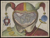
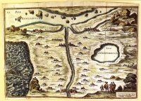
| - | [[Image:Carte du tendre.jpg|thumb|right|200px|The ''[[Map of Tendre]]'' (''Carte du Tendre'') is a French map of an [[imaginary country]] called ''[[Tendre]]'' produced by several hands (including [[Catherine de Rambouillet]]). It appeared as an engraving (attributed to [[François Chauveau]]) in the first part of [[Madeleine de Scudéry]]'s 1654-61 novel ''[[Clélie]]''. It shows a geography entirely based around the theme of [[love]] according to the [[Précieuses]] of that era: the river of Inclination flows past the villages of "Billet Doux" ([[love letter|Love Letter]]), "Petits Soins" (Little Trinkets) and so forth.]] | + | [[Image:Fool's Cap World Map by anonymous.jpg|thumb|left|200px|''[[Fool's Cap World Map]]'' (c. 1590s) by anonymous]] |
| + | {| class="toccolours" style="float: left; margin-left: 1em; margin-right: 2em; font-size: 85%; background:#c6dbf7; color:black; width:30em; max-width: 40%;" cellspacing="5" | ||
| + | | style="text-align: left;" | | ||
| + | "[[War]] is God's way of teaching Americans [[geography]]."--Paul Rodriguez | ||
| + | <hr> | ||
| + | "OUR [[earth]] is but as an atom in [[space]], a star amongst stars. Yet, to us who inhabit it, it is still without bounds, as it was in the time of our [[primitive people|barbarian ancestors]]. Nor can we foresee the period when [[terra incognita|the whole of its surface will be known to us]]."--''[[The Earth and Its Inhabitants]]'' (1875–1894) by Élisée Reclus | ||
| + | |} | ||
| + | [[Image:Carte du tendre.jpg|thumb|right|200px|The ''[[Map of Tendre]]'' (''Carte du Tendre'') is a French map of an [[imaginary country]] called ''[[Tendre]]''. It shows a geography entirely based around the theme of [[love]]]] | ||
| {{Template}} | {{Template}} | ||
| The study of the physical [[structure]] and [[inhabitant]]s of the [[Earth]]. | The study of the physical [[structure]] and [[inhabitant]]s of the [[Earth]]. | ||
| + | |||
| + | ==History== | ||
| + | The [[ancient Greeks]] divided the world into three [[continents]], [[Europe]], [[Asia]], and [[Libya]] (Africa). | ||
| + | |||
| + | The [[Hellespont]] formed the border between Europe and Asia. The border between Asia and Libya was generally considered to be the Nile river, but some geographers, such as Herodotus objected to this. Herodotus argued that there was no difference between the people on the east and west sides of the Nile, and that the [[Red Sea]] was a better border. The relatively narrow habitable band was considered to run from the Atlantic Ocean in the west to an unknown sea somewhere east of India in the east. The southern portion of Africa was unknown, as was the northern portion of Europe and Asia, so it was believed that they were circled by a sea. These areas were generally considered uninhabitable. | ||
| ==See also== | ==See also== | ||
| * [[Flat earth]] | * [[Flat earth]] | ||
| Line 8: | Line 20: | ||
| * [[Cartography]] | * [[Cartography]] | ||
| * [[List of explorers]] | * [[List of explorers]] | ||
| - | * [[List of geographers]] | ||
| * [[Map]] | * [[Map]] | ||
| * [[Navigator]] | * [[Navigator]] | ||
| + | * [[Psychogeography]] | ||
| * [[World map]] | * [[World map]] | ||
| {{GFDL}} | {{GFDL}} | ||
Current revision

|
"War is God's way of teaching Americans geography."--Paul Rodriguez "OUR earth is but as an atom in space, a star amongst stars. Yet, to us who inhabit it, it is still without bounds, as it was in the time of our barbarian ancestors. Nor can we foresee the period when the whole of its surface will be known to us."--The Earth and Its Inhabitants (1875–1894) by Élisée Reclus |

|
Related e |
|
Featured: |
The study of the physical structure and inhabitants of the Earth.
History
The ancient Greeks divided the world into three continents, Europe, Asia, and Libya (Africa).
The Hellespont formed the border between Europe and Asia. The border between Asia and Libya was generally considered to be the Nile river, but some geographers, such as Herodotus objected to this. Herodotus argued that there was no difference between the people on the east and west sides of the Nile, and that the Red Sea was a better border. The relatively narrow habitable band was considered to run from the Atlantic Ocean in the west to an unknown sea somewhere east of India in the east. The southern portion of Africa was unknown, as was the northern portion of Europe and Asia, so it was believed that they were circled by a sea. These areas were generally considered uninhabitable.
See also

