Image:Carte du tendre.jpg
From The Art and Popular Culture Encyclopedia
Carte_du_tendre.jpg (246KB, MIME type: image/jpeg)
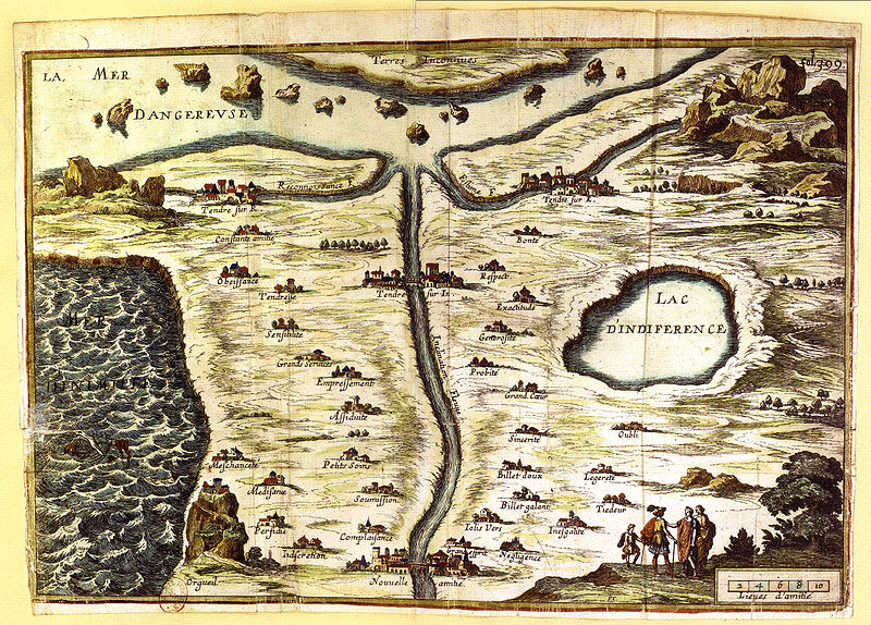
The Map of Tendre (Carte du Tendre) is a French map of an imaginary country called Tendre produced by several hands (including Catherine de Rambouillet). It appeared as an engraving (attributed to François Chauveau) in the first part of Madeleine de Scudéry's 1654-61 novel Clélie. It shows a geography entirely based around the theme of love according to the Précieuses of that era: the river of Inclination flows past the villages of "Billet Doux" (Love Letter), "Petits Soins" (Little Trinkets) and so forth.
File history
Legend: (cur) = this is the current file, (del) = delete
this old version, (rev) = revert to this old version.
Click on date to see the file uploaded on that date.
- (del) (cur) 14:57, 21 March 2010 . . Jahsonic (Talk) . . 800x574 (251485 bytes) (Category:PD)
- Edit this file using an external applicationSee the setup instructions for more information.
Links
The following pages link to this file:
- French literature
- Lipstick Traces
- Fiction
- Sensibility
- Tender
- Emotion
- Fantasy
- Imagination
- Fantasy (psychology)
- Love
- Concept
- Country
- Fantasy literature
- Template:Bibliography
- Main Page
- Map of Tendre
- Catherine de Vivonne, marquise de Rambouillet
- Précieuses
- Madeleine de Scudéry
- Salon (gathering)
- Geography
- Arcadia (utopia)
- Sentimentalism
- Sentimentality
- Sentimental novel
- Gallantry
- Fantasy world
- Fictional universe
- Love letter
- Affection
- Travel
- Sentimentalism (literature)
- Propensity
- Tendency
- Place
- Topography
- Terrain
- Inclination (ethics)
- Parallel universes in fiction
- Location
- Clelia
- Travel literature
- Terra incognita
- 17th-century French literature
- Fictional country
- Surface
- Voyage
- Fictional location
- Cartography
- The Dictionary of Imaginary Places
- Territory
- Map–territory relation
- Worldbuilding
- Imaginary voyage
- Map
- Philosophy of love
- Sentimental cartography
- François Chauveau
- Land
- Fantasy cartography
- Lists of places
- List of philosophical concepts
- Paracosm
- Mental representation
- Pictorial map
- Visual novel
- Terra
